 |
Angklung is a renowned musical instrument made of bamboo and its originated is West Java, Indonesia. In the early days, music played an essential part of ceremonial activities, especially in the harvest times. The sound of bamboos is believed will catch the attention of the goddess Sri – who will bring fertility to the plantation, and pass the joy and happiness for mankind. The oldest Angklung in history that still exist is called Angklung Gubrag made in Jasinga, Bogor, and has reached 400 years of age. Nowadays, some of those older Angklung remain in Sri Baduga Museum, Bandung. As the time flown by, Angklung is not only recognized throughout Indonesia, also, spreading to other Asian countries. Current days, many contemporary and young musicians compose music through the brilliant sound of bamboo. |
Angklung Originaly From Indonesia
March 6, 2009 at 3:24 am (Indonesia, Travel, Uncategorized)
Tags: Archipelago, Borneo, Celebes, Indonesia, Irian Jaya, Java, Jawa, Kalimantan, Maluku, Molucas, NKRI, Papua, Republik Indonesia, Sulawesi
Batik Originaly From Indonesia
March 6, 2009 at 3:23 am (Indonesia, Travel, Uncategorized)
Tags: Archipelago, Borneo, Celebes, Indonesia, Irian Jaya, Java, Jawa, Kalimantan, Maluku, Molucas, NKRI, Papua, Republik Indonesia, Sulawesi

Batik is generally thought of as the most quintessentially Indonesian textile. Motifs of flowers, twinning plants, leaves buds, flowers, birds, butterflies, fish, insects and geometric forms are rich in symbolic association and variety; there are about three thousand recorded batik patterns.
The patterns to be dyed into the the clothe are drawn with a canting, a wooden ‘pen’ fitted with a reservoir for hot, liquid wax. In batik workshops, circles of women sit working at clothes draped over frames, and periodically replenish their supply of wax by dipping their canting into a central vat. Some draw directly on the the cloth from memory; others wax over faint charcoal lines.
This method of drawing patterns in wax on fine machine-woven cotton was practiced as a form of meditation by the female courtiers of Central Java; traditionally, batik tulis (tulis means ‘write’ in Indonesian) is produced by women.
In the 19th century, the application of waxed patterns with a large copper stamp orcap saved the batik industry from competition with cheap printed European cloth. The semi-industrial nature of cap work allows it to be performed by men. Batik motifs recall characters from the Hindu epics, plants, animals, sea creatures and gamalan melodies.

In Surakarta rich creams and browns are juxtaposed with tinges of yellowish gold.White, undyed cloth is left to contrast with the sombre opulence of brown and blue dyes in Yogjakarta. The palette of the north coast were influenced by lively maritime trade and the textile traditions of the Chinese and Arab mercantile communities living in port and coastal towns.
The Symbolic Meaning of Batik’s Motifs
The motifs of Batik, especially with old pattern, as in other field of Javanese tradition are symbolizing something. Might be, this is one of the reasons, why people still adore batik up to present date. Some of the motifs are :
- Sido Mulyo :
Sido (you should be ), mulyo (happy). Symbolizing ‘you should be happy and rich man’. - Sido Dadi :
Symbolizing ‘you should be a man/woman as you wish (prosperous, high ranking position, wealthy, etc)’. - Satrio Wibowo :
Symbolizing ‘Man with dignity’. - Tikel Asmorodono :
Tikel (more), Asmoro (love), Dono (gift).
It is meant the one who wears this batik, should be loved more and more by others.
The Process of Batik Making
Batik, in Javanese means ‘To Dot’. Basically there are two kinds of batik; Batik Tulis (hand drawn) and Batik Cap (stamped). The price of batik tulis is much more expensive than batik cap.

Doting
A canting (a pen like instrument with a small reservoir of liquid wax) is applied to the cloth of batik tulis making. The tracing of the desired design on to the prepared cloth is the first stage of making followed by the technique of applying wax and dye substances. At the final stage of the process, all the wax scraped off and the cloth boiled to remove all traces of the wax. This process of repeatedly waxing and dyeing is the batik process, used until nowadays in Java and other parts of Indonesia.
So, this kind art of batik is an indigenous to the country. The wax used in batik process is a combined product of paraffin, bees-wax, plant resins called gondorukem and mata kucing.
Batik cap, which is also using the waxing process, its process of course faster and easier. But people appreciation of batik tulis is higher, it is really a work of an artist not only a craftsman. It combines the expertise, patience, deep feeling to produce the finest product, and it may take days, weeks and even months to make only a batik tulis
The Cities of Batik
Yogyakarta and Solo are the centers of traditional of batiks, as the north coastal town of Pekalongan is the center of more modern batiks, using more floral and birds motifs. There are some well-known artists of batik design in Yogya and Solo, as well as some big batik manufacturers with famous trademarks.
The growing production of batik makes way to the establishment of mori (woven cotton fabrics) factories in Yogya and Central Java. The Batik research Institute was founded in Yogya.
When Batik is Worn
Batik dresses are worn for several purposes, such as ;
- Informal Dresses
It is a free choice, usually for daily casual wear. - Formal Occasions
In some parties, as a state banquets, receptions, etc, the invitees are requested to wear batik. Long sleeves shirts for the men and ‘kain batik’ (long batik to cover the lower body) for the women. - Traditional Occasions
It is worn to present the traditional wedding ceremonies, special ceremonies for the Royal families, etc.
In a wedding ceremony the bride and the bridegroom wear the same motif of batik Sidomukti, symbolizing a happiness and prosperous life. Using the same motif symbolizing the togetherness. The parents of the bride and the bridegroom wear batik with motif of Truntum, symbolizing the advice of the parents to the newly weds to enter the new life with full of love and confidence.
Traditional Dress
Women’s traditional dress, especially in Yogya and Solo court families, consisting of :
- Jarit or Tapih or Sinjang
A ‘kain panjang’ (long cloth of batik) measuring around 2 m x 1 m to cover the lower body, tightened with stagen (large waist band) - Kebaya
It is a traditional long sleeved shirt (the material used is not from batik, usually from silk and other fine materials). - Selendang
It is used as attractive piece of clothing to compliment the traditional dress. The 2 m x 0,5 m selendang cloth hung over one shoulder. - Kemben or Semekan
It is special for ceremonies in Karaton (palace) or Royal family ceremonies. Instead of wearing Kebaya, to cover the upper body, a kemben is worn.
Men’s Traditional Dresses
- Jarit or Bebed
Men kain panjang, tightened with stagen. - Surjan
Men traditional long sleeved shirt (only for Yogya style) and the material is not batik. - Beskap
Instead of wearing surjan, the men wear a coat (beskap of Solo style or Atila of Yogya style), the materials is not batik. - Blangkon
It is a headgear made from batik. - Keris
The dagger is worn at backside of the waist, as a compliment to the dress.
Dodot
Is a very long jarit to cover the lower body. It is worn only on a very special occasion such as the king coronation by the king himself. The wearing of dodot or kampuhan is very complicated. It may take two hours to wear a dodot with the help of specialist-dressers!
Toba Lake
March 6, 2009 at 3:21 am (Indonesia, Travel, Uncategorized)
Tags: Archipelago, Batak, Indonesia, Medan, NKRI, North Sumatra, Republik Indonesia, Sumatra, Toba, Toba Lake

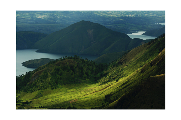
Toba Lake
World famous is the crater Toba Lake in the Batak highlands; approximately five hours drive from Medan. Toba Lake is the largest lake in South East Asia and also one of the most spectacular, surrounded by tall mountains and with the large island of Samosir in the middle. If we descend from the mountain we see the lake glittering in all its beauty. The Dutch writer Rudy Kousbroek even called Toba Lake, ‘the most beautiful place on earth’. Most visitors stay on the peninsula of Tuk Tuk on Samosir, named after the linguist Herman Neubronner van der Tuuk. In general people stay several days on Samosir to discover the island, to visit traditional Batak villages, to swim in the lake and go to the hot springs in Pangururan.
The cen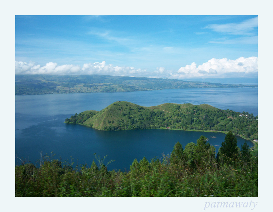 terpiece of North Sumatra, Lake Toba’s bracing climate and magnificent panoramas clear the mind and soothe the soul. For decades a magnet from regional and foreign visitors alike, Toba has developed into a full-featured highland resort while retaining the rustic charm and relaxed ambiance that define Toba’s attraction. Formed by a stupendous prehistoric volcanic explosion, the 100 km long lake is the largest in Southeast Asia and one of the deepest and the highest in the world. The drama of that cataclysmic birth persist in 500 meter cliffs dropping into the blue-green waters, surrounded by steep, pine covered sloped, the climate is fresh and pleasant, with just enough rain to support the lush vegetation.
Toba Lake is a 100kms x 30kms volcanic lake in North Sumatra, Indonesia. Toba Lake has become one of the main tourist attractions for a long time in North Sumatra apart from Bukit Lawang and Nias, visited by both domestic and foreign tourist.
Puncak
March 6, 2009 at 3:13 am (Indonesia, Travel, Uncategorized)
Tags: Archipelago, Bogor, Indonesia, Java, Jawa, NKRI, Puncak, Republik Indonesia
Between Bandung and Bogor in the mountains lays Puncak, a cool area, which is very popular. People from Jakarta spend their weekend and on public holidays from the heat and busy streets of the capitol of Indonesia to Puncak. Bandung to Puncak takes about 3 hours drive. Puncak Pass area has long been the foremost weekend retreat for Indonesians capital city residents. The cool, fresh air, and the magnificent view offer a calm, fresh and peaceful feeling. In the afternoon, sunsets from the top of the pass can be quite spectacular.
Puncak Pass is one of interesting destination in the West Java Province. It is located in the south of Jakarta and can be reached by an hour journey. Puncak is an ideal place for weekend, as well as a good location to find a fresh mountain air. Besides, many attractions can be found nearby, such as the Bogor and Cobodas Botanical Gardens; the Gede Pangrango National Park; the Plantations and the Safari Park.
Puncak Indah consists of three districts: Ciawi, Megamendung, Cisarua. The area is familiar with its fresh air and beautiful panorama. From Ciawi to Cipanas, there are many bungalows, hotels, motels, restaurants, and other tourism facilities. Tourisms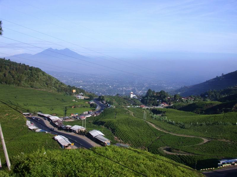 object in Puncak is Lido Park, which is located in Cigombong village/Wates Jaya (km. 21) Rd. Ciawi-Sukabumi, Cijeruk. Facilities that are provided in Lido Park ara restaurant, cottages, swimming pools, camping grounds, and other facilities for lake recreations. Gunung Mas XII Plantation, which is located in Rd. Puncak, Cisarua district. It offers panorama with hilly panorama, which could only be found in Puncak. Activities that could be done are tea walk and seeing the making of the tea from the picking of tea until the tea is ready to serve.
Musi River
March 6, 2009 at 3:08 am (Indonesia, Travel, Uncategorized)
Tags: Archipelago, Indonesia, Musi River, NKRI, Republik Indonesia, Sumatra
 Musi River
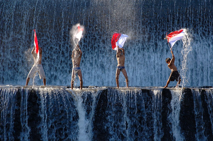
Musi River is both very broad as well as long, comparable to those found on the big island of Kalimantan, formerly Borneo. The river flows right through the city, cutting it in two halves called the Ulu bank and the Ilir bank and linked by a bridge of considerable size and length, called Ampera Bridge. If the visitors do not care to make an interesting or unique boat trip down the river, they could still take a walk halfway over the bridge to see the vast panorama surrounding them, rare at any other place in Indonesia. Down below they will see unbelievable traffic of boats, big and small, crisscrossing water lines without accidents as if steered by the most able navigators. From the same spot both halves of the city are clearly visible as well. And if the times were right, sunrises and sunsets as witnessed from the bridge would be an unforgettable sight of beauty. Worthwhile noticing are the floating restaurants and shops on both sides of the river, and other curious scenes of daily habits of the city’s inhabitants. There is an annual event, which is held around the Independence Day, each 17th of August, and is known as Bidar Race in which boats measuring 24.5 m long and only 0,75 m wide compete. Each boat carries as many as 50 oarsmen.
Introducing Indonesia
February 6, 2009 at 6:54 am (Indonesia)
Tags: Archipelago, Bali, Borneo, Indonesia, Java, Jawa, Kalimantan, Maluku, NKRI, NTB, NTT, Papua, Republik Indonesia, Sulawesi, Sumatra
Introducing Indonesia
Adventure looms large in this vast and steamy archipelago, where the best of Southeast Asia’s spicy melange simmers tantalisingly. Heady scents, vivid colours, dramatic vistas and diverse cultures spin and multiply to the point of exhaustion, their potent brew leaving your senses reeling.
Rippling across the equator for nearly 5000km, Indonesia encompasses more than 17,000 islands, two-thirds of which are inhabited and richly layered with character. On Sulawesi, the elaborate funeral ceremonies and timeless traditions of Tana Toraja are light years from the surfing culture of Lombok. But so too are the mighty saddle-backed Batak mansions of Danua Toba and the volcanic lakes of Sumatra from the mummies and deeply etched gorges of Papua’s Baliem Valley. The resorts and restaurants of Bali pamper precocious style cats, while at the same moment threadbare backpackers are adopted by homestays in Kalimantan.
Indonesia’s cities are in a constant state of urban evolution, where dense populations, technology and construction live in hectic symbiosis. But most of the archipelago’s territory remains unexplored, concealing a wealth of cultures and a myriad of landscapes. Oceanic rice fields and ancient sultanates in Java are humbled by haunting volcanic cones. Maluku’s alabaster beaches and desert islands remain pristine while the tourist trail heads elsewhere. The jungles of Sumatra, Kalimantan and Papua are zoological wonders, revealing impish monkeys, stoic sun bears, leopards, orang-utans and remarkable marsupials.
And then there are the micromoments, equally exquisite but entirely unexpected; impromptu English lessons with school children, instant friendships in crammed bemos, lending an ear to your becak rider… In Indonesia there is plenty of cause to pause, except when dodging hurtling traffic – but that’s all part of the adventure.
Introducing Bali
February 6, 2009 at 6:36 am (Indonesia)
Tags: Bali, Indonesia, Kuta
Introducing Bali
Bali may be small in size – you can drive around the entire coast in one long day – but its prominence as a destination is huge, and rightfully so. Ask travellers what Bali means to them and you’ll get as many answers as there are flowers on a frangipani tree. Virescent rice terraces, pulse-pounding surf, enchanting temple ceremonies, mesmerising dance performances and ribbons of beaches are just some of the images people cherish.
Small obviously doesn’t mean limited. The manic whirl of Kuta segues into the luxury of Seminyak. The artistic swirl of Ubud is a counterpoint to misty treks amid the volcanoes. Mellow beach towns like Amed, Lovina and Pemuteran can be found right round the coast and just offshore is the laid-back idyll of Nusa Lembongan.
As you stumble upon the exquisite little offerings left all over the island that materialise as if by magic, you’ll see that the tiny tapestry of colours and textures is a metaphor for Bali itself.
And those are just some of the more obvious qualities. A visit to Bali means that you are in the most visitor-friendly island of Indonesia. There are pleasures of the body, whether a massage on the beach or a hedonistic interlude in a sybaritic spa. Shopping that will put ‘extra bag’ at the top of your list. Food and drink ranging from the freshest local cuisine bursting with the flavours of the markets to food from around the globe, often prepared by chefs and served in restaurants that are world class. From a cold Bintang at sunset to an epic night clubbing in Kuta, your social whirl is limited only by your own fortitude.
Oh yha,by the way I have video about Bali.
Bali 28 – 1st Asian Beach Games by Bali 2008
The Togian Islands
February 6, 2009 at 6:34 am (Indonesia)
Tags: Indonesia, Sulawesi, Togian
The Togian Islands


From April to October, the cruises are located in the Togian Islands, inside the large Tomini Bay. The Togians include 3 main volcanic islands close together, and another one apart on the North that erupted last in 1984, as well as numerous islets. It is the only place in the world where barrier reefs, atolls, and fringing reefs are found together. Most of the islands is still covered by dense tropical forest, human settlements and tourism are still very limited.
The Togian islands dives specificity is certainly the beauty and the diversity of the underwater sceneries their offer, with a visibility that is generally very good.
Around the volcanic island of Una-Una, where we stay for 3 days, sponges size and shape diversity are astonishing, probably among the biggest in the world. The fish life is very dense: schools of jacks and barracudas, Bump head parrotfish’s, numerous napoleon wrasses, snappers, fusiliers, etc.
Other dive sites include beautiful drop offs with crevasses and overhangs, canyons, rocks formations, pinnacles, all offering a great variety of spectacular underwater sceneries.
Pelagic life is present on some of the spots with schools of barracudas, tunas, giant trevallies, eagle rays, reef sharks and sometimes hammerhead sharks.
)
The development and the diversity of coral formations are also a highlight of the Togian islands. The cruise also includes a visit to an intact plane wreck B24 from the 2nd World War laying on the bottom at eighteen meters depth.
Our twelve days cruise, EXT TOG, covers the 8 days Togian cruise and ends in Luwuk, spending four more days of diving along the eastern tip of the peninsula that separates Tominy bay from Luwuk area. The dive sites of this area -we are the only dive operators there- are mostly rocky formations and pinnacles with an intense marine life and a high density of fishes including pelagic as tunas and giant jacks. Abundant gorgonians, soft corals and daisy corals make also those dives very colorful. For a more precise description of the Peninsula dive sites, please refer to the Banggai Cruise section.

Examples of diving sites we visit during the Togian cruise:
NB. Most of the dive sites that are walls or slopes can be dive at different depth according to the diver’s level and wishes, and if the dive is a morning or an afternoon dive. That’s why we sometime mention a depth range rather than a maximum depth.
Dominik rock; Kadidiri Isl., depth 110 feet
It is a rocky formation outside the barrier reef (the barrier reef runs along almost all the north coast of Togian islands). We leave the bottom of the reef wall at a depth of 55 feet and follow the sandy bottom in between massive rocks, where we frequently spot giant groupers. The last rock, at 100 feet depth, makes a wall on its outside part falling in the deep blue, from where are coming up tunas and schools of jacks. We then follow the top of this rock that forms a flat platform covered with colorful soft corals, sponges and splendid huge gorgonians. The dive then go back to the reef wall that we follow, getting slowly up until the lagoon where we finish the dive.
Fishomania; Una-Una Isl., depth 40 – 80 feet
Una-Una is a volcanic island in the North of the Togian group. The volcano last eruption was in 1984, and since then human settlements are theoretically forbidden on the islands. In fact, a few inhabitants stay there, taking care of the numerous coconut trees on the lower part of the island, the upper part being covered by dense tropical forest.
Fishomania is a pinnacle with a top a 12 feet deep, where aggregates high densities of fishes: we generally spend a few minutes hanging on some rocks in the current, looking at the non remitting and hypnotic ballet that forms schools of fusiliers, surgeons fishes, snappers, jack fishes and so many others. The outside part of the pinnacle forms a splendid wall covered by dense coral formations of all shapes and colors, associated with sponges of uncommon size and shape.
Turtles and Napoleons are usually spotted, as well as eagle rays and white tips sharks.
Manara 1, Una-Una Isl., 45 to 90 feet
On the Una-Una barrier reef, it is a slope offering a luxuriant hard coral coverage. Another highlight of this dive is a white gorgonian field at 90 feet depth, at the beginning of the dive. Same as on the other sites of Una-Una, you will find a dense fish life all along the dive.
Apollo reef, Una-Una isl, 90 feet
A reef formation on a sandy slope, from 25 to 35 meters depth. As on the other dives on Una-Una, there is always a lot of fishes (schools of surgeons, fusiliers, Napoleon wrasses) but the highlight of the dive is huge schools of barracudas (more than one thousand ?) that comes to check and surround the divers.
Kololio, Una-una isl, 30 feet Night dive
We mention this night dive because in addition to the critters, we generally see turtles, sleeping parrot fishes -including bump head parrot- wrasses, and many other fishes interesting for portraits.
Mimpi Ding-Ding, Pasir Tengah atoll, depth 65 to 100 feet
You dive straight down along an absolutely vertical wall that goes down to abyssal depth (but not you, even though the temptation is hard to resist!). The deep and transparent blue of the water -the visibility is generally excellent- gives to this dive a special fantasy ambient. This the archetype of the “wall”, where hang huge tubes and barrel sponges , black corals, where are cruising tunas, eagle rays, ascending and descending schools of Platax and trevallies. The wall also presents beautiful overhangs and crevasses. This a also a typical dive profile of the tropics where you slowly get up along the wall and finish your tanks at the top of the reef looking at the aquarium.
Goa-goa, Pasir tengah atoll, depth 55 feet
Another wall, with a lot of overhangs and horizontal faults. A very good site for photographers, with a good coverage of soft corals. A large swim through at 40 feet deep, with walls and ceiling covered by bright yellow siphonogorgias. The wall between 6 and 3 meters, where we spend the last twenty minutes of the dive, is colonized by an amazing quantity of various nudibranches.
Batu Gila (“Crazy stone”), 100 feet
A special spot for pelagics outside the barrier reef of Kadidiri. A reef with a top at -27 mts, on a sandy bottom of about 70 mts. When the currents are strong at certain periods of the tide, the fish life is very dense: Schools of jacks, barracudas, white tips, grey reef sharks and sometime hammerheads. Due to the strong currents , this dive is only offered to experienced divers.
Gunung laut, South Togians, Depth 80 feet
Coming up from a bottom of more than 200 meters, this pinnacle that culminates at -27 meters is visited by numerous pelagic fishes: tunas, white tips and grey reef sharks, schools of jacks. Beautiful coverage of soft corals.
This area has several pinnacles that are probably all good diving sites, but we practice only two of them. Some room for exploration, mention it on board if you are interested.
B24 liberator, South Togians, depth 60 feet
The wreck, a American B24 bomber from the Second World War, lays almost intact on a 18 meters bottom. The plane was on its way back to its base on Morotai Island (North Mollucas) when an engine went on fire. The pilot managed to alight on the waters of this calm bay. All the crew was safe and went to the land where the local people rescued them.
A large school of jacks is always on the spot; shrimps, glass fishes, crocodile fishes.
For more information : http://www.wallacea-divecruise.com/togians.html
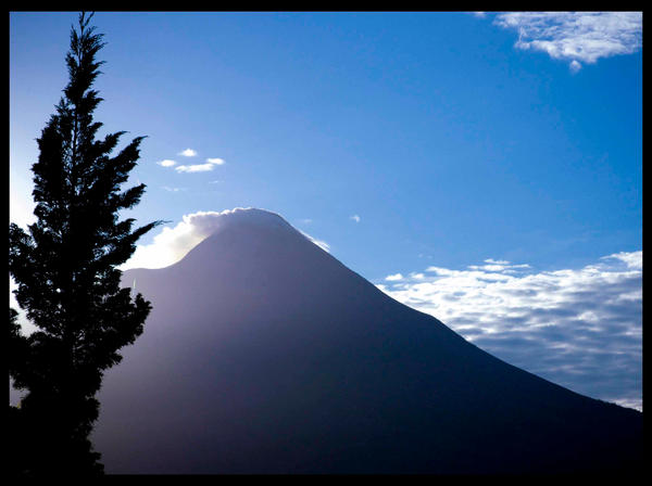
Mount Bromo
February 6, 2009 at 6:32 am (Indonesia)
Tags: Indonesia, Mount Bromo

Mount Bromo
Bromo isn’t the highest mountain in Java — that honor goes to nearby Mount Semeru at 3,676m — but it’s probably the most famous one. Bromo is in fact only one of many peaks inside the massive Tengger Caldera, but it’s easily recognized as the entire top has been blown off and the crater inside constantly belches white sulphurous smoke. The inside of the caldera, aptly dubbed the Laut Pasir (Sea of Sand) is coated with fine volcanic sand and the overall effect is unsettlingly unearthly, especially when compared to the lush green valleys all around the caldera.
Orientation
The major access point is Cemoro Lawang at the northeast edge, but there are also trails from Tosari (northwest) and Ngadas (west). The village of Ngadisari, on the road from Probolinggo about 5.5 km before Cemoro Lawang, marks the entrance to the national park. Both Cemoro Lawang and Ngadisari are rather picturesque, with brightly-painted houses and flower beds outside.
See & Do

When timing any activities in the area, bear in mind that sunset is soon after 5 PM and sunrise is correspondingly early at around 5:30 AM. This means you’ll usually need to get up by 3:30 AM or so to get there in time for dawn.
- Mount Batok (2440m) is a brown volcanic cone at the north center of the caldera. Unlike the other nearby peaks it is no longer active and actually has some vegetation growing on it, mostly the local cemara tree that somehow manages to survive even on volcanic ash.
- Mount Bromo, edges tinged with white sulphur and always bubbling, is the main sight. To reach it on foot, pick the left fork at Cemoro Lawang’s solitary crossing, then head down the ramp into the caldera and then across the caldera to the Hindu temple at the foot of the mountain. From the temple a steep path of 250 steps leads to the edge of the crater and a precarious meter-wide ledge from where to gaze into the volcano. Beware of local jeep-hirers, who often try to persuade tourists the journey to the mountain is not walking distance (in order to hire them jeeps, or horses). The walk from the tourist centre to the top of the mountain should take no longer than 1.5 hours by foot, and is about 3km.
- Mount Penanjakan (2770m), located just north of the caldera, is a mountaintop viewpoint accessible by paved road from Tosari and hence popular with jeeps and even tour buses. Most of the crowd comes to see the dawn at 5 AM, and you’ll likely have the large concrete observation post to yourself if you arrive later in the day.
- Viewpoint #2, along the trail from Cemoro Lawang to Mt. Penanjakan, is an excellent way to get a stunning view of the caldera (see pictures above) without the crowds. To reach it, head west from Cemoro Lawang (past Cemero Indah) for 6 km, past farms and fields. The paved road eventually turns into a twisty mountain trail that ends with a flight of stairs on the right, and the viewpoint (with concrete shelter) is at the top. Allow 1.5 hours for the climb up at a steady pace, and bring along a torch if attempting this at night.
- From here, you can continue onto Mt. Penanjakan by following the trail upward, after which the trail merges onto the paved road to the viewpoint (total time about 60 minutes one way). If planning to return the same way, mark the spot where the trail emerges onto the road (if you pass a stone lantern on the way down, you’ve gone too far!), and note that descending on this section can get slippery due to loose sand and rocks.
The Raja Ampat Islands
February 6, 2009 at 6:30 am (Indonesia)
Tags: Indonesia, Raja Ampat
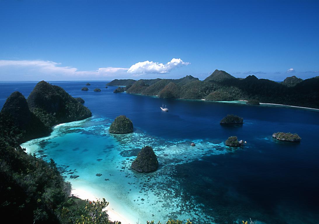
The Raja Ampat Islands
In the Heart of the Coral Triangle
The Raja Ampat, or “Four Kings,” archipelago encompasses more than 9.8 million acres of land
and sea off the northwestern tip of Indonesia’s West Papua Province. Located in the Coral Triangle, the heart of the world’s coral reef biodiversity, the seas around Raja Ampat possibly hold the richest variety of species in the world.
The area’s massive coral colonies show that its reefs are resistant to threats like coral bleaching and disease —threats that now jeopardize the survival of corals around the world. In addition, Raja Ampat’s strong ocean currents sweep coral larvae across the Indian and Pacific Oceans to replenish other reef ecosystems. Raja Ampat’s coral diversity, resilience to threats, and ability to replenish reefs make it a global priority for marine protection.
Survey Confirms Highest Marine Biodiversity on Earth
In 2002, The Nature Conservancy and its partners conducted a scientific survey of the Raja Ampat Islands to collect information on its marine ecosystems, mangroves, and forests. The survey brought Raja Ampat’s total number of confirmed corals to 537 species— an incredible 75% of all known coral species. In addition, 899 fish species were recorded, raising the known total for Raja Ampat to an amazing 1,074. On land, the survey found lush forests, rare plants, limestone outcroppings, and nesting beachesfor thousands of sea turtles.
Though human impacts here are less severe than elsewhere in Indonesia, Raja Ampat’s natural resources are endangered by over fishing and destructive fishing, turtle poaching, and unsustainable logging. The Indonesian government recently established Raja Ampat as a separate administrative unit, which will give communities a greater say in managing the natural resources upon which their livelihoods depend. This structure also offers an important opportunity to include conservation in the spatial planning of the newly formed local government.
Ensuring Conservation through Partnerships
To address these issues, the Conservancy launched a new project to protect Raja Ampat, working in close partnership with the government and communities to: 1) contribute to a comprehensive conservation action plan to protect Raja Ampat’s reefs and forests; 2) help incorporate marine protected area management into long-term planning and policy; and, 3) establish a network of marine protected areas for Raja Ampat.
The Conservancy’s ultimate goal is to protect Raja Ampat’s magnificent reefs while sustaining the livelihoods of local people. Raja Ampat includes the four large islands of Waigeo, Batanta, Salawati, and Misool, plus hundreds of smaller islands. The archipelago is part of an area known as the Bird’s Head functional seascape, which also contains Cenderawasih Bay, the largest marine national park in Indonesia.
